
NOTE: This is PART 2 of this unit.
PART 1 covers weather, instruments, weather maps, depressions and anticyclones. These are lessons 1 - 7. |
PAWhat are hurricanes? Why do they form? Why was hurricane Katrina so devastating? What is microclimate? Do buildings really make the area warmer and trees make it cooler? We're going to answer all these questions and finish off with studying the weather in Malta!
The lessons covered in PART 2 of this unit are: 8. Hurricanes 9. Case study: Katrina 2005 10. Microclimate 11. The Maltese Islands Weather |
8. HURRICANES
|
🡺 List the causes of the origin of a typical tropical storm.
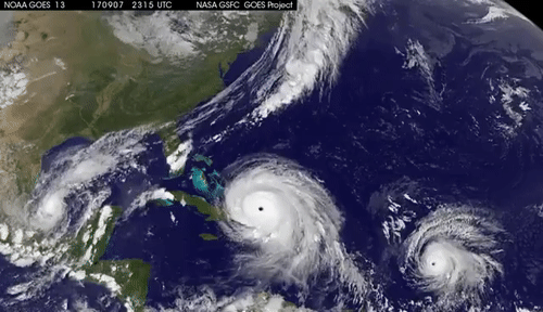
🡺 Analyse the main features of a hurricane. 🡺 Aware of the destructive effects of a tropical storm including, high winds, storm or tidal surges, flooding and landslides Tropical cyclones are areas of intensive low pressure. They can be called hurricanes, typhoons or cyclones. Where hurricanes develop
How hurricanes form
EFFECTS Winds
Landslides
Flooding
Storm surges
|
|


Geo-check!
|
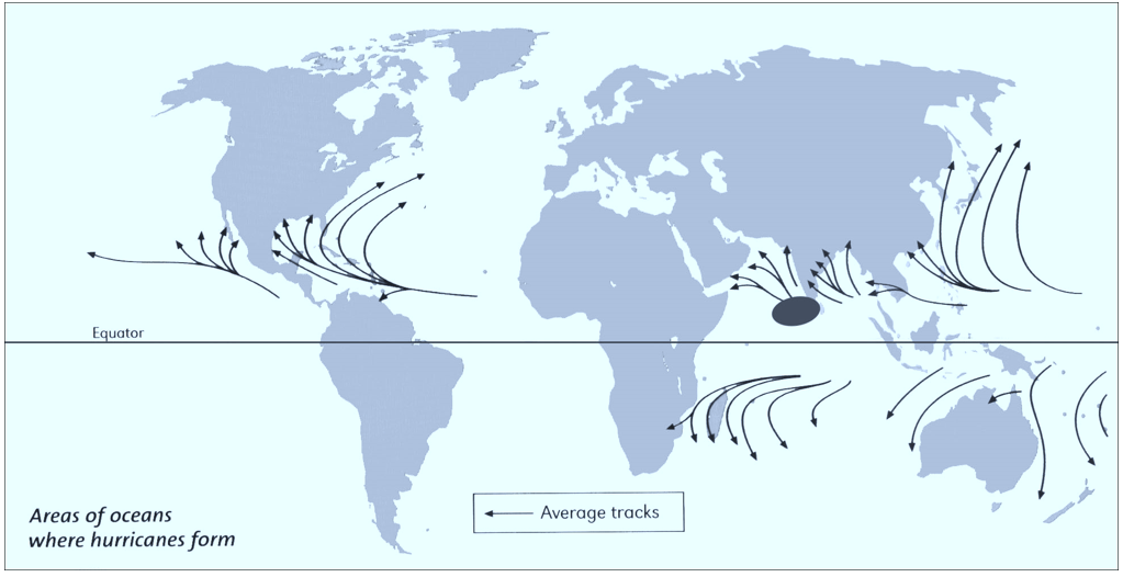
1. The map shows areas of oceans where hurricanes form. On the outline map draw carefully the eight hurricane source areas. One of the areas has been done for you.
|
|
|
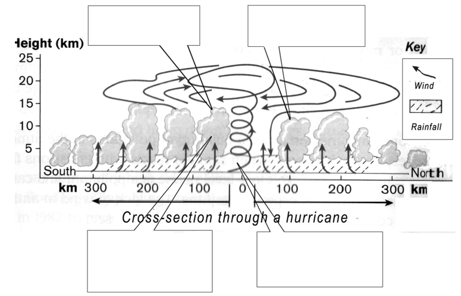
2. The diagram below shows a simplified cross-section through a hurricane.
a. Add these key words to continue the paragraph. [tides 300km winds energy cools rain eye calm clouds] Warm, damp air spirals upwards towards the top of the hurricane from the ocean below. As the air rises it ___________________ and water vapour condenses, forming thick ___________________ . This releases huge amounts of heat ___________________ which powers the storm. The central area has very low pressure, but it is ___________________ and clear and is known as the ___________________ of the storm. Very strong ___________________ blow outwards from the eye, reaching up to 300km per hour. Hurricanes also bring torrential ___________________ and very high __________________ known as storm surges. Hurricanes can be as much as 800km in diameter, but the worst wind and rain is usually in a belt ___________________ wide. b. Then add the labels below to the diagram.
|
|
|
3. Continue the following sentences explaining were hurricanes form and develop.
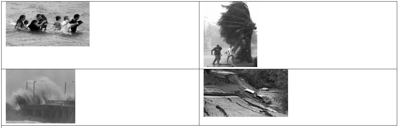
4. By referring to the photos here write about the four main hazards associated with hurricanes. |
|

9. CASE STUDY: KATRINA 2005
|
🡺 Locate the origin and course of hurricane Katrina.
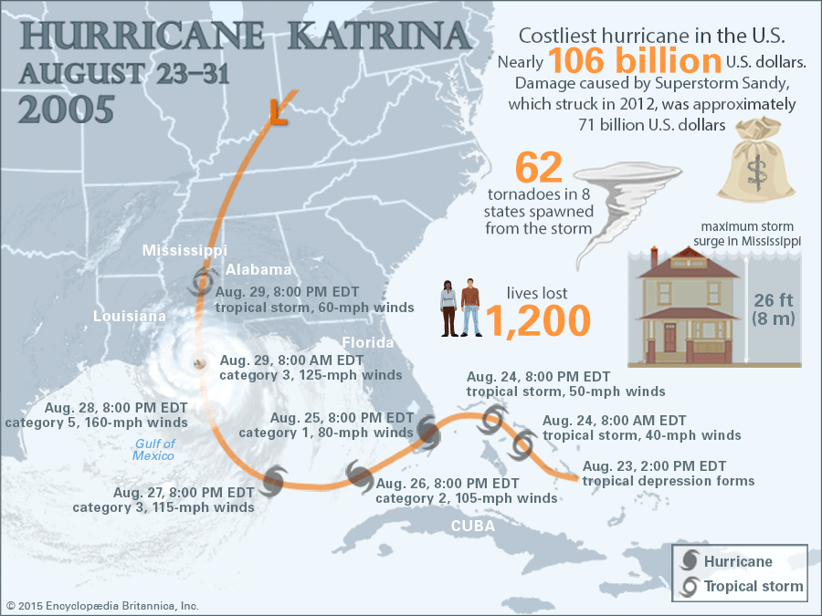
🡺 Describe the weather conditions over New Orleans during the storm. 🡺 List the destructive results of hurricane Katrina as they affected the population, building and property, places and the economy in general. Hurricane Katrina hit landfall on 29th August 2005 and quickly became known as one of the most expensive natural disasters in the history of the USA. Effects on People
Effects on Property
RESPONSES
|
|


|

|
Geo-check!
|
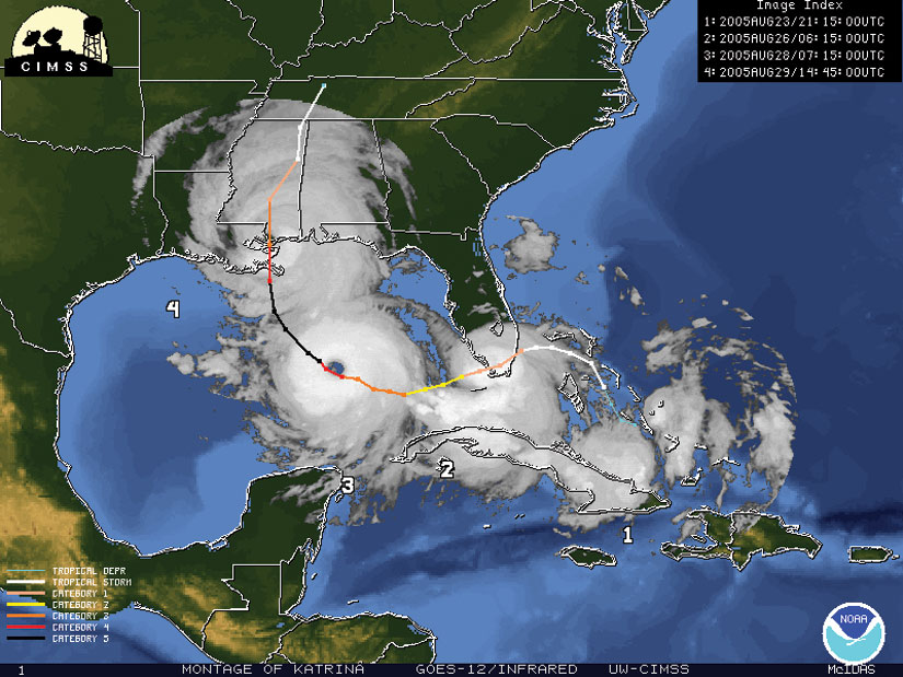
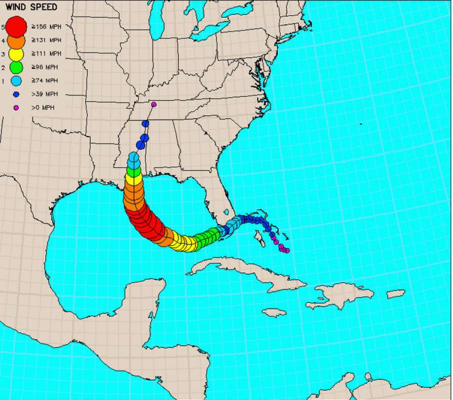
1. The photo shows the track taken by Hurricane Katrina. On the satellite photo itself mark:
|
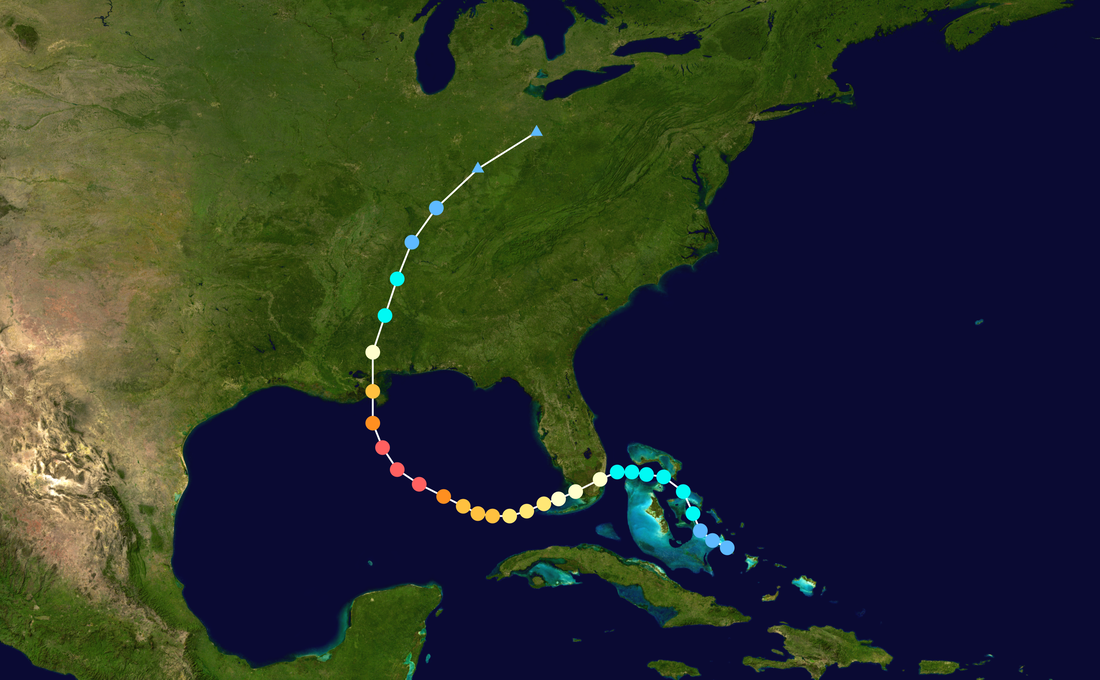
|
|
2. Using the information provided by the newspaper article answer the following questions and the fact file below.
HURRICANE KATRINA Place: Date: Dead: Homeless: Cost: a. Where did Hurricane Katrina begin? b. What were the maximum wind speed reached by Hurricane Katrina? c. In which direction did Hurricane Katrina travel? d. Name the countries and states that were affected by Hurricane Katrina. e. Storm surges are caused by hurricanes. Explain what is meant by the term ‘storm surge”? f. Describe the hazards other than storm surges, which are caused by hurricanes. g. List the destructive results of Hurricane Katrina as it affected the population, property and the economy in general. |
HURRICANE KATRINA BRINGS DISASTER
30 October 2005 In August 2005 Hurricane Katrina devastated the states of Mississippi, Louisiana and Alabama making it one of the costliest and deadliest hurricanes in the history of the USA. The death toll reached 1,836 people besides hundreds of thousands of people homeless. Damage was caused by strong winds of up to 280 km per hour, heavy rain and storm surges. Most damage was caused by floods which swept away everything in their path and caused landslides. The floods destroyed towns, villages, roads, bridges and buildings. On August 23rd 2005 Hurricane Katrina formed over the Bahamas as a circulating cloud system, powered by warm moist air from the sea. The tropical storm continued to move towards South Florida, where it hit as a category 1 hurricane with 130 km/h winds. Rainfall was heavy, in places exceeding 350mm and a storm surge of 2 metres was measured. More than 1 million were left without electricity and damage in Florida was estimated between 1.5 billion dollars, with most of the damage coming from flooding and overturned trees. There were 14 fatalities reported in Florida as a result of Hurricane Katrina. Although Hurricane Katrina stayed well to the north of Cuba, on August 29th it brought tropical storm force winds and rainfall of over 200 mm to parts of the island. Telephone and power lines were damaged and around 8,000 people were evacuated from coastal parts. The storm rapidly intensified after entering the Gulf of Mexico because of the storm’s movement over warm waters and became one of the strongest hurricanes on record while at sea. A state of emergency was declared in Louisiana, Alabama and Mississippi two days before the hurricane made landfall. By Sunday 28th August, most infrastructure along the Gulf Coast had been shut down including railways as well as the Waterford Nuclear Power Station. About 1.2 million residents of the Gulf Coast were ordered to evacuate the coastal areas. On the morning of August 29 Katrina hit the states of Louisiana and Mississippi. The maximum winds of 280 km/h caused storm surges along the Gulf Coast subsequently flooding 80% of New Orleans. Two-thirds of the flooding were due to levee breaches. Hurricane Katrina also brought heavy rain to Louisiana with 250 mm falling in a short period of time. As a result of the rainfall and storm surge the level of Lake Pontchartrain rose and caused significant flooding affecting several communities. Several bridges were destroyed including the I-10 Twin Bridge. Almost 900,000 people in Louisiana lost power. Levee breaches in Orleans also caused widespread loss of life. The Gulf coast of Mississippi also suffered massive damage from the impact of the hurricane on the 29th August leaving 238 people dead, 67 missing and billions of dollars in damage: bridges, boats, piers, houses and cars were washed inland. It caused a powerful 8.2 m storm surge which penetrated inland for more than 15km. The storm also brought heavy rains with 250 mm falling in SW Mississippi and caused eleven tornadoes which damaged trees and power lines. 90% of the structures within a kilometer of the coastline were completely destroyed. Casinos which were floated on barges were washed hundreds of metres inland by waves. A number of streets and bridges were also washed away. The storm surge at Alabama measuring 3.7 metres caused significant flooding several kilometers inland. Ships, oil rigs, boats and fishing piers were washed ashore. An offshore oil rig broke its moorings and grounded on a nearby island. Hurricane Katrina weakened as it moved inland but still caused minor damage in several regions. The economic effects of the storm were far-reaching. The storm is estimated to have been responsible for $81.2 billion dollars in damage making it one of the costliest natural disaster in US history. It was also responsible for the destruction of the Gulf Coast’s highway and the export of grain were highly affected. Katrina also damaged 30 oil platforms and caused the closure of 9 refineries. Katrina also had profound impact on the environment. The storm surge and the waves from Katrina caused substantial beach erosion and barrier islands were completely obliterated. About 20% of the marshes were permanently overrun by water as a result of the storm. The lands that were lost were also breeding grounds for marine mammals, brown pelicans and turtles. |

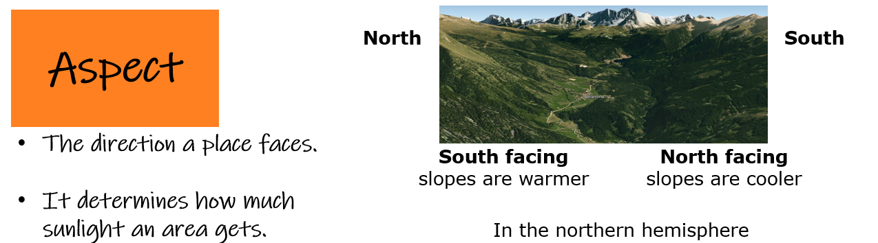
10. MICROCLIMATE
|
Describe the particular climate of a large city including lower wind speeds, more clouds, slightly higher rainfall because of dust, less snowfall, more convection leading to heavy rainfall, more surface run-off, water vapour and smog.
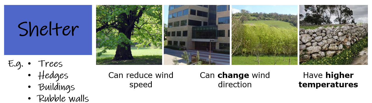
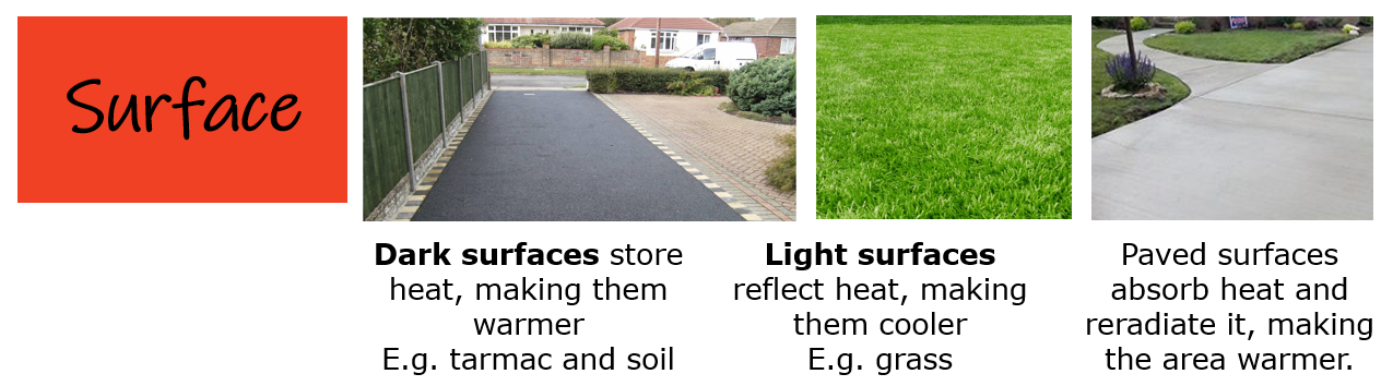
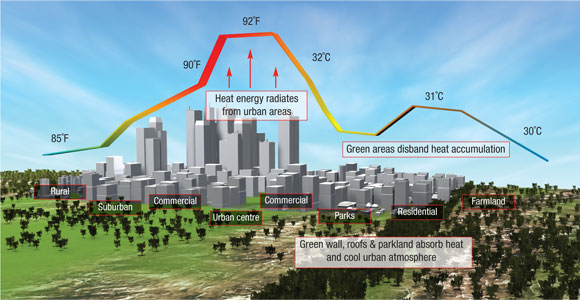
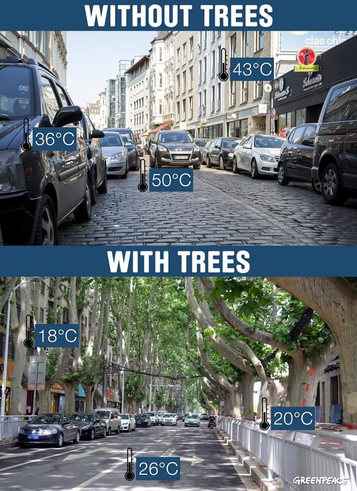
Define and explain the term urban heat island. Within a climatic region, the climate may vary from place to place, eg the top of a hill, the sunny side of a hill, the shaded side of a hill and the bottom of a hill. When the climate in a small area is different to the general surrounding it is called microclimate. Physical features such as water areas can have a cooling effect on the land. Trees can shade the land, also making it cooler. Human features such as walls and buildings will shelter against the wind, making it warmer. Buildings which are heated may also give out heat (radiate), which again makes it warmer than the surrounding landscape. Due to human activity, the temperature in an urban microclimate is higher than that of the surrounding areas. Urban areas are said to be urban heat islands as under calm conditions, temperatures are highest in the built-up city centre and decrease towards the suburbs and countryside. 
Heat map for Paris

Heat map for Toronto
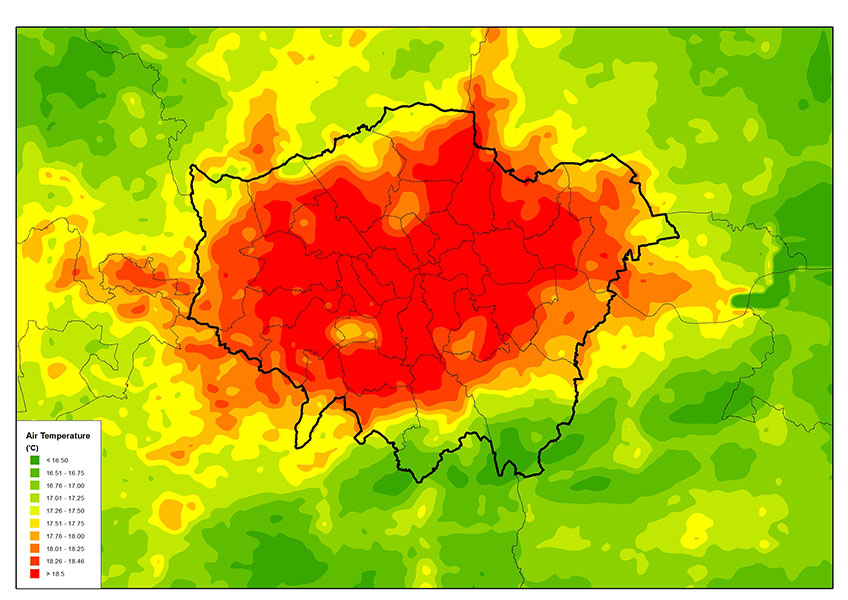
Heat map for London
|

|
|
|
Geo-check!
|
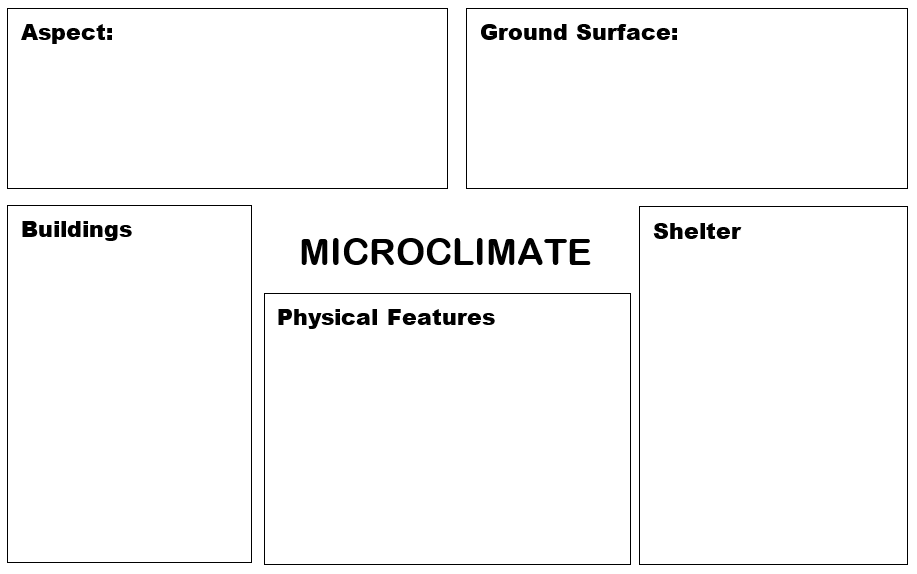
1. Fill in the diagram here with the main causes for different microclimates.
|
|
|
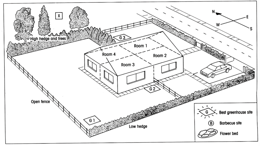
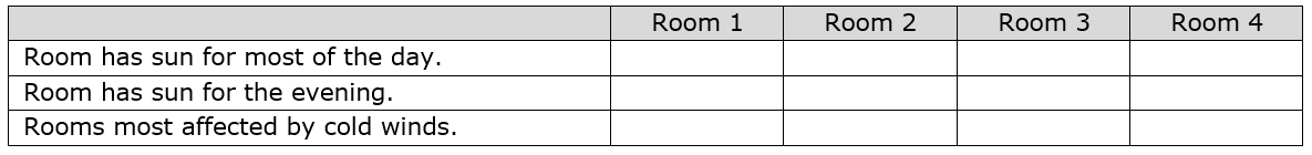
2. Imagine that you have just moved into the house shown below.
Remember that in Malta North winds are usually cold. The sun rises in the east, is in the south at midday and sets in the west. a. Draw an arrow at point X to shoe the direction of the cold northerly wind. b. Colour in the part of the house that gets sun for most of the day. c. Tick the boxes in the table on the right d. Which room/place in the garden should the following be placed? Why?
|
|
|
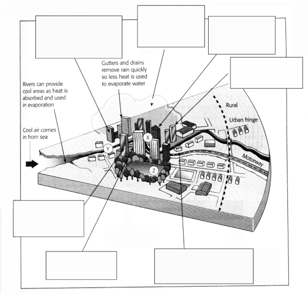
3. Place the following labels in the correct place on the diagram to identify the factors that help to explain this.
|
|
|
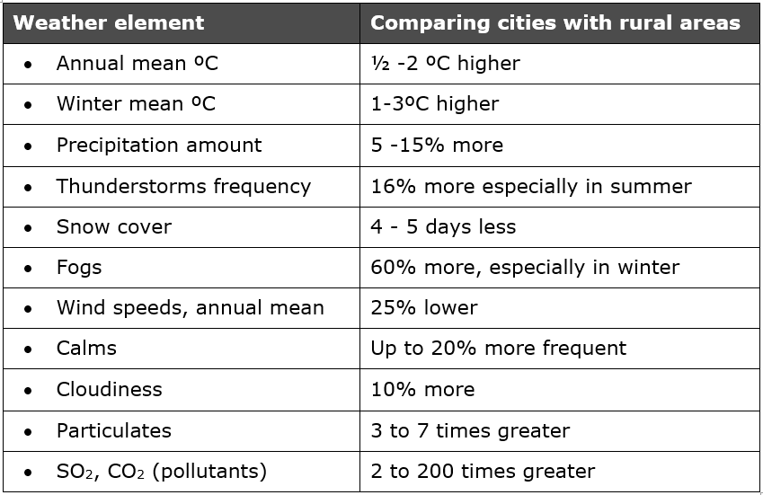
4. Cities alter the weather and have their own microclimates. The table below shows the average climate changes produced by cities.
a. What of the weather elements are increased in a city? b. What of the weather elements are decreased in a city? |
|
|
5. Fill in the spaces explaining what the main causes of an urban heat island are.
|
Urban areas have higher _________________. Temperatures may reach _________________ higher than the surrounding countryside. It is called urban _________________ . Higher temperatures occur because many buildings and pavements are made of ________________ materials.
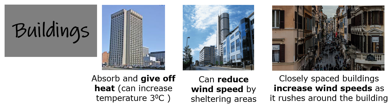
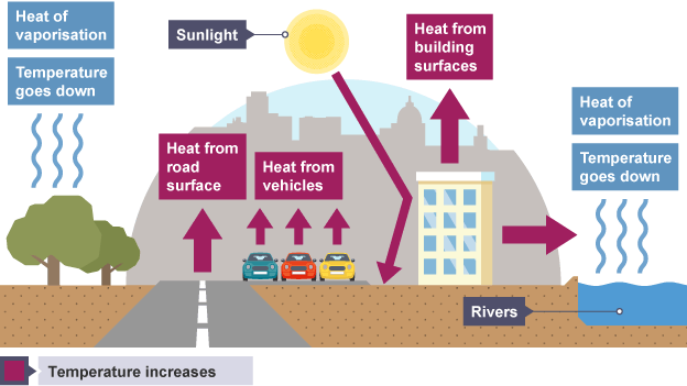
These absorb the _________________ raising their temperature and that of the air around them. This heat is then __________________ at night. Cities are densely populated areas, full of houses, industries, factories, offices and cars which release large amounts of heat into the atmosphere. The quality of _________________ in cities is generally poor. Towns and cities are more _________________ than the countryside. Motor vehicles, ________________ , industry and domestic sources all produce pollution in urban areas. These pollutants rise into the lower atmosphere creating ________________ , a mixture of smoke and fog especially during the summer months. Poor air quality affects people's _________________, for example making asthma worse. Many cities also tend to be ________________ than surrounding rural areas. Higher temperatures lead to ________________ air currents which create unstable air. Dust from the city forms nuclei around which water vapour _________________ and then falls as rain which can be accompanied by ___________________. Buildings in the city affect the wind _________________. Although buildings may act as _________________ to wind, skyscrapers may disrupt air flow, creating _____________ and currents since wind is channelled between buildings and often through narrow gaps. The result is that cities often have more _______________ wind than in the country. |

11. THE MALTESE ISLANDS
🡺 Interpret a simple climate graph of the Maltese Islands
🡺 Interpret the distribution of wind direction on a wind rose.
🡺 Recognise the difference between convectional and frontal rainfall as experienced in Malta.
🡺 Interpret the distribution of wind direction on a wind rose.
🡺 Recognise the difference between convectional and frontal rainfall as experienced in Malta.
Geo-check!
|
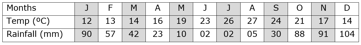
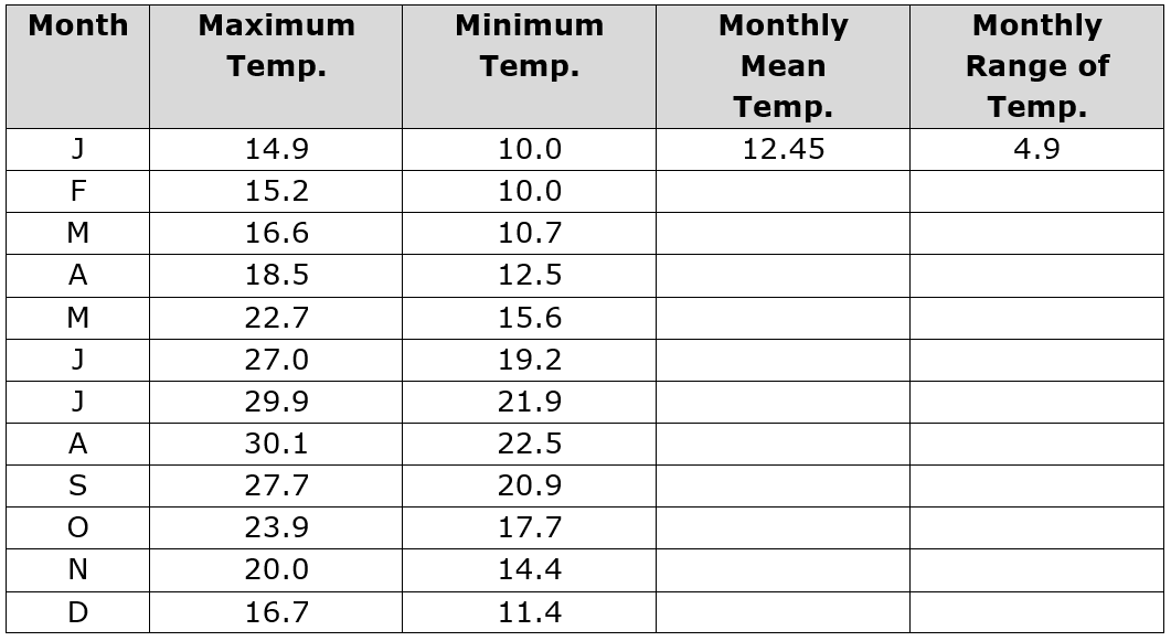
1. Using the data provided, plot a climate graph for Malta. Make sure that your graph has labels, title and is drawn neatly and accurately.
|
|
2. Study the climatic chart for Malta, and state whether the following statements are true or false.
a. Average monthly temperatures are always higher than 20ºC.
b. July and August are the warmest months.
c. Average monthly temperatures decline steadily from October till January.
d. The warmest months are the wettest.
e. Summer is the rainy season.
f. December is the wettest month of the year.
g. There is over 26mm of rainfall in August.
h. May to August is the driest four-month period.
i. Total rainfall exceeds 800mm per year.
j. Summers are cold with temperatures of about 26ºC.
k. The hottest months are the driest.
l. Drought is experienced in the months of October and November.
|
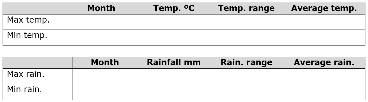
3. Fill in the following tables:
4. Briefly describe the climate of the Maltese Islands by referring to the temperature and rainfall data provided. 5. From the graph you have drawn which part of the year suffered the most drought? Give reasons for your choice. |
|
|
6. The data below shows the average annual maximum and minimum temperatures.
a. Fill in the table here. b. Then find out:
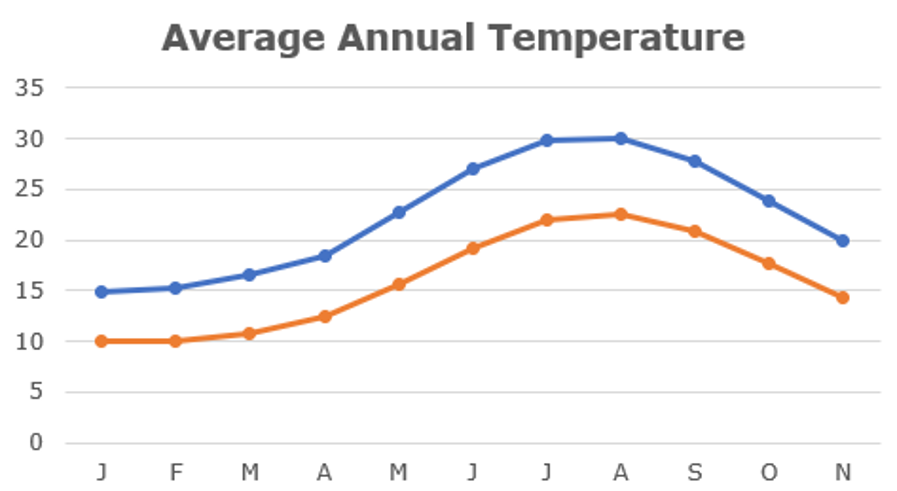
|
|
|
7. The diagram below shows a simple wind rose. The main purpose of a wind rose is to record wind direction for a specific place. It consists of a circle, each side of which represents a cardinal point. The wind rose is drawn to scale such that the length of each arm represents the wind frequency and the diameter of the central circle represents the number of calm days.
Fill in the blanks. 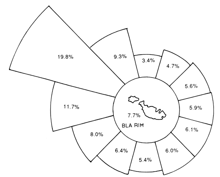
|
The Maltese Islands are definitely windy.
The days when no wind blows are very few, and on average, there are only ______% of the days in a year. This means that in a whole year there are only ______ days which are calm. The most common wind in all seasons is the _______________ known in Maltese as _______________ . It blows for an average of ______% of the days in a year. This wind is (cold/warm/hot) in winter, but in summer it is (hot/cool/cold) and refreshing. Next in frequency are winds blowing from the _______________ with a percentage of ______ and the North-northwest. The rest of the days that is ______%, are equally shared by other winds. The _______________ wind known as grigal in Maltese, blows for 4.7% of the days throughout the year. It is a (cold/warm) wind that blows with great force and violence and lasts for stretches of about (ten, three, eight) days at a time. It is also accompanied by (rain, drought) and stirs up the sea into violent storms. The winds that blow from the south are unpleasant for they bring with them humid and (cold/freezing/hot) air. These include the south-east wind. The south-wind known in Maltese as _______________ blows for ______% of the days. This wind together with the south-east originates in the North African _________________ and usually is (hot/cold) and (wet/dry). These unpleasant winds are usually dust-laden and are accompanied by ______________ rain. |
|
8. Refer to the following wind roses for the months of January and August. Are the following statements are true or false?
|
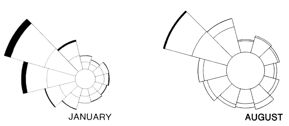
|
|
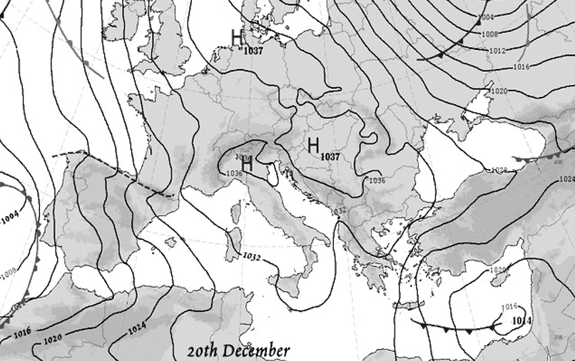
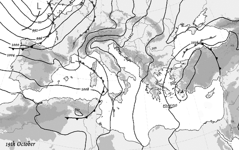
9. Look at the weather map dated 20th December.
a. Complete the following sentences.
b. What does the pattern of isobars tell us about wind speed? c. Give a simple weather forecast for Malta. d. Describe the weather that this same system may bring to Malta on a summer's day. |
|
|
11. Study the weather chart below.
a. Complete the following sentences.
b. On the weather map itself shade all areas experiencing rainfall. c. In which direction is the depression close to Malta moving? d. During the next few hours the depression will move over Malta. Describe the sequence of weather experienced in Malta during this time. e. What type of rainfall is characterised by a depression? f. Explain why it rains at the warm and cold fronts in depressions. |
|
|
12. Read the following brief account of one of the frequent storms that hit Malta.
a. Explain what caused the storm of 1979. b. Describe the effects of the storm that hit Malta on the 25th October 1979. |
THE STORM OF 1979
One of the worst storms ever to hit the Maltese Islands occurred on Thursday 25th October 1979. During this storm the Meteorological Office reported that 68.2mm of rain was recorded at Luqa between 3 p.m. and 7 p.m. on this day. The storm was caused after cold currents from the Northeast Atlantic found their way to the Central Mediterranean and met with warmer currents coming up from the Libyan desert. This storm claimed four victims. At Misrah Kola, Attard, a woman died in her basement when water flooded her house and trapped her; a man was carried away by the waters at Qormi after abandoning his car; the third and fourth victims were English tourists who were drowned when floodwater sank the cars they were driving. The heavy rain and intermittent lightning caused damage to roads, houses, and a large number of cars. There was no electricity supply in various parts of the Islands. At the Marsa Sports Club around 30 people were isolated by deep water and helicopters had to be used to rescue them. The airport was closed to all traffic for about 90 minutes as visibility was reduced to a few metres. |
|
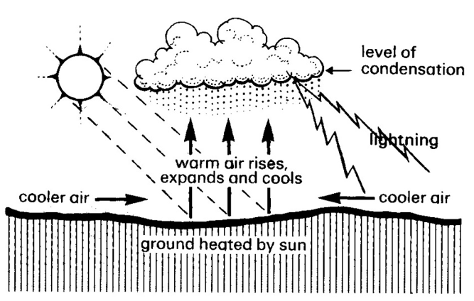
13. Another type of rainfall experienced in Malta, especially in late summer) is known as Convectional Rainfall. With the help of the diagram fill in the blank spaces below to explain how convectional rainfall forms.
Convectional rainfall is caused by the intense heating of the ground surface by the ___________________ . The warm air expands becomes lighter than the surrounding air and therefore _________________ in a convection current. As the air rises, it _________________ and its water vapour __________________ into deep cumulo-nimbus clouds. Such rainfall creates ____________________ downpours accompanied by ___________________ and thunder. |
|

