
|
Ever wondered why volcanoes and earthquakes happen in similar place? And why are there mountains going all the way from Spain to India? How is this topic related to the Ice Age movies? Who was Alfred Wegner and what was his great idea?
This is definitely one of the most eye-opening topics. Be prepared to never look at Google Earth in the same way ever again! The lessons covered in this unit are: 1. Structure of the earth 2. Continental drift 3. The major plates 4. Constructive margins 5. Destructive margins 6. Conservative margins 7. Fold mountains 8. Earthquakes, volcanoes and plate boundaries |
1. STRUCTURE OF THE EARTH
|
🡺 I can recognise the core, mantle and crust in a diagram representing a cross section of the Earth.
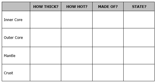
🡺 I can describe the basic characteristics of the core, mantle and crust. 🡺 I can differentiate between the main characteristics of oceanic and continental crust. Before you learn about how the earth works on the outside, you need to know what's inside it! The Earth is made up of four distinct layers. 1. Inner Core
There are two types of crust. Continental Crust
|

|
Geo-check!
|
1. Use the words in the box below to fill in the gaps below.
iron three molten mantle magma centre crust The earth is made up of ____________layers, the crust, the _____________ and the core. The core is in the _____________ of the earth and is made of __________________. The mantle is made up of _____________rocks called _____________. The ____________ is the part we live on and is between 8 and 60 km thick. 2. Fill in the table here. 3. How can you tell that it is hot inside the earth? |
|

2. CONTINENTAL DRIFT
|
🡺 I am able to explain the idea that the world’s continents were once joined in a large super-continent.
🡺 I understand the reason why plates move, i.e. convectional currents in the mantle. Alfred Wegener was a German climatologist and arctic explorer who suggested the concept of continental drift. Continental drift is the idea that the continents move around on Earth’s surface. Although Wegner’s continental drift was a good hypothesis, at the time it was rejected by other scientists. Now we have enough evidence that tells us that he was correct, such as:
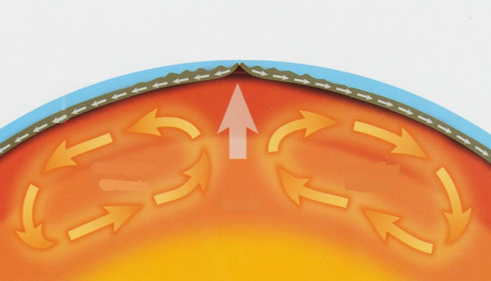
The surface of Earth is broken into many pieces like a giant jigsaw puzzle. Each of these pieces is called a plate. Plate tectonics describes how these pieces move on Earth’s surface. The heat from the inner core causes the lower mantle area to heat up. As it is heated, the magma expands, becomes less dense and rises. As it reaches the crust, it starts becoming cooler and sinks again. The process continues to repeat. These are known as the convection currents in the mantle. These convection currents move the plates. Where convection currents diverge near the Earth's crust, plates move apart. Where convection currents converge, plates move towards each other. |


|
Geo-check!
1. Watch the Animated Life Pangea, Wegener, and Continental Drift — HHMI BioInteractive video and complete these sentences.
- Alfred Wegener was ...
- He notices that the continents on the map ...
- He thought that the continents fit into each other because ...
- At that time, other scientists ...
- Label the diagram on the right.
- Explain how convection currents move the continents in at least 60 words.
- What happens when a plate subducts under another one?

3. THE MAJOR PLATES
🡺 I can identify the major plates of the earth’s crust
On the right you can see a map of the main tectonic plates. The point where two plates meet is called a plate boundary.
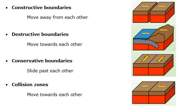
There are four types of plate boundaries.
On the right you can see a map of the main tectonic plates. The point where two plates meet is called a plate boundary.
There are four types of plate boundaries.

|
|
Geo-check!

1. Study the map and fill in the blanks below with two examples of the four plate boundaries.
Constructive boundary
Destructive boundary
Conservative boundary
Collision zone
2. Which plate boundary do you think is most dangerous to humans? Why?
Constructive boundary
- Between the _________ Plate and the _________ Plate
- Between the _________ Plate and the _________ Plate
Destructive boundary
- Between the _________ Plate and the _________ Plate
- Between the _________ Plate and the _________ Plate
Conservative boundary
- Between the _________ Plate and the _________ Plate
- Between the _________ Plate and the _________ Plate
Collision zone
- Between the _________ Plate and the _________ Plate
- Between the _________ Plate and the _________ Plate
2. Which plate boundary do you think is most dangerous to humans? Why?

4. CONSTRUCTIVE MARGINS

🡺 I can describe what tectonic events or landforms happen at this boundary.
🡺 I can give examples of this types of boundary.
🡺 I can draw a labelled diagram and explain this type of boundary.
At constructive margins, two plates move away from each other. Magma rises to fill in the gap and forms new oceanic crust.
TECTONIC ACTIVITY
Gentle volcanoes and earthquakes
EXAMPLE
Eurasian Plate and North American Plate
- The Eurasian Plate and North American Plate are moving apart causing the Mid-Atlantic ridge.
- The Atlantic Ocean is widening by 3cm every year. This is called sea floor spreading.
- In November 1963 there was an explosion under the sea near the Westman islands. After many explosions, it became the island of Surtsey.
Geo-check!
|
1. Give TWO examples of constructive margins from the map on the right.
2. Label the diagram on the right with these phrases. Make sure it has a title.
3. Explain the tectonic activity at this boundary. |


|

5. DESTRUCTIVE MARGINS
|
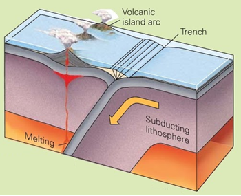
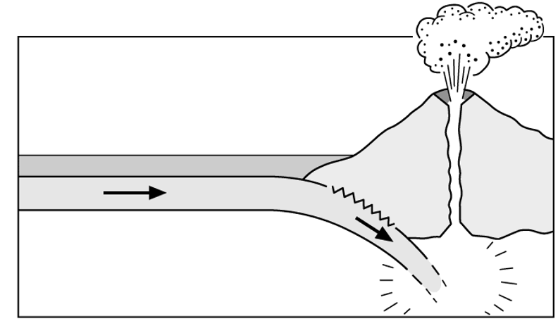
🡺 I can describe what tectonic events or landforms happen at this boundary.
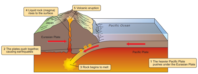
🡺 I can give examples of this types of boundary. 🡺 I can draw a labelled diagram and explain this type of boundary. In a destructive boundary, two plates move towards each other. As the oceanic crust moves toward continental crust, the oceanic crust is heavier and sinks. This forms a subduction zone and a deep-sea trench. The subducting oceanic plate melts and causes pressure to build up. Volcanoes, fold mountains and earthquakes occur. TECTONIC ACTIVITY Violent volcanic events and earthquakes. EXAMPLES South American Plate and Nazca Plate
Pacific Plate and Eurasian Plate
|
|
Geo-check!
|
1. Give TWO examples of destructive margins from the map on the right.
2. Label the diagram on the right with these phrases. Make sure it has a title.
3. Explain the tectonic activity at this boundary. |
|

6. CONSERVATIVE MARGINS
|
🡺 I can describe what tectonic events or landforms happen at this boundary.
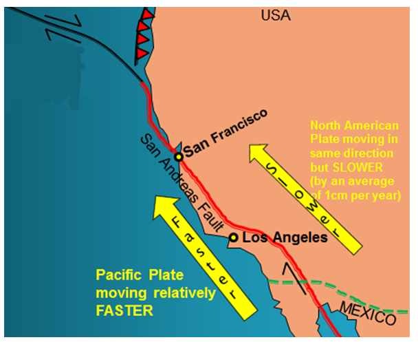
🡺 I can give examples of this types of boundary. 🡺 I can draw a labelled diagram and explain this type of boundary. A conservative margin happens when two plates slide past one another. New landforms are not created here. Earthquakes happen when the plates ‘stick’. When pressure builds up, it is released by sending shockwaves / earthquakes to the surface. TECTONIC ACTIVITY Violent earthquakes. No volcanoes. EXAMPLE North American Plate and the Pacific Plate
|

|
Geo-check!
|
1. Give TWO examples of conservative margins from the map on the right.
2. Label the diagram on the right with these phrases. Make sure it has a title.
3. Explain the tectonic activity at this boundary. |


|

7. FOLD MOUNTAINS
|
🡺 I can describe what tectonic events or landforms happen at this boundary.
🡺 I can give examples of this types of boundary. 🡺 I can draw a labelled diagram and explain this type of boundary. 🡺 I can locate the distribution of major fold mountain ranges Fold mountains happen when two plates of continental crust move towards each other. Both plates are forced upwards to form fold mountains. These areas have many earthquakes. TECTONIC ACTIVITY Violent earthquakes. No volcanoes. EXAMPLE Eurasian Plate and Indian Plate

|
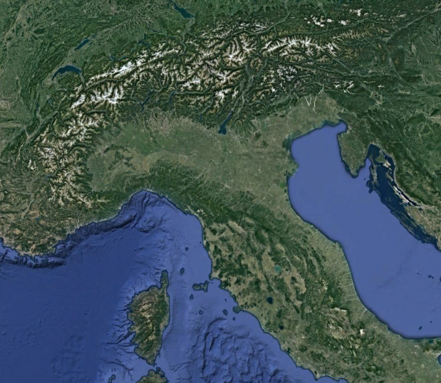
Alps - Fold mountains between the Eurasian and African Plate
|
Geo-check!
|
1. Give TWO examples of collision margins from the map on the right.
2. Label the diagram on the right with these phrases. Make sure it has a title.
3. Explain the tectonic activity at this boundary. 4. Around the Mediterranean there are ranges of mountains formed in the same way as the Himalayas. a. On the satellite image of the Mediterranean below mark the following mountains. You can use the internet or an atlas to help you.
b. These mountains are composed of sedimentary rocks. Explain how these rocks are now found so high above sea-level. |


|


8. EARTHQUAKES, VOLCANOES AND PLATE BOUNDARIES

🡺 I can compare world maps showing the location of plate boundaries, volcanoes and recent major earthquakes.
🡺 I recognise earthquakes and volcanoes as a result of plate movements.
Earthquakes are found along all types of plate margins as shown on this map.
Volcanoes however, only occur at constructive and destructive plate margins.
A lot of volcanic activity occurs in the 'ring of fire'.
The 'ring of fire' is a group of volcanoes that are located along the plate margin of the Pacific plate.
Geo-check!
|
1. Highlight FIVE of these phrases which describe the distribution of the world’s volcanoes and earthquakes:
2. Volcanoes on this map are marked as triangles. Show the ‘Ring of Fire’ on the map. 3. Tectonic activity occurs in certain patterns. How can you describe this pattern? Use at least 60 words. 4. Explain how you can tell that South America and Africa have moved apart. |

|

