
|
In this unit, we're going to learn all about maps! Reading a map is like reading - the more you read and practice, the better you get at it! What are you waiting for? Let's start!
The lessons covered in this unit are: 1. The legend 2. Compass and directions 3. Scale and distance 4. Grid references |
1. THE LEGEND
|
🡺 I can gather information about a place from a map and legend.
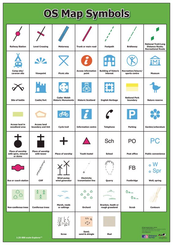
A map is a two-dimensional drawing of an area. Maps help us to understand what places are like and how to plot routes. If anyone wants to reap the full benefit of a good map, they should be able to read it. Reading a map is like reading a book or a newspaper. In both cases, one should know certain simple rules and do a lot of practice. Maps are full of information and this is presented in different ways. The inside of a good map is always filled with very useful information and most of this is given in the form of symbols. Symbols are a form of shorthand so that each symbol on the map stands for a particular object on the real land. A key to these signs is always included in the margin of the map. The key or legend is essential because it helps the map user learn what each symbol stands for. |
|
Geo-check!
|
1. Look at the map called Around Mosta and answer the following questions.
a. Mention two places of historical interest on the map b. Mention two places of religious interest on the map c. Mention two places of geographical interest on the map d. Explain how main roads and secondary (smaller) roads are shown differently on the map. 2. Look at the map called The countryside and say if these statements are TRUE or FALSE. Add another 2 statements ( g and h). a. The woods have two roads close by. b. The windmill is closer to the river than it is to the road. c. The beach is very close to a settlement. d. The lighthouse is on an island. e. The marsh is almost surrounded by a river. f. The largest settlement has 6 roads coming out of it. g. [ADD A STATEMENT] h. [ADD A STATEMENT] 3. Explain how a key will help you to understand more about the map. |
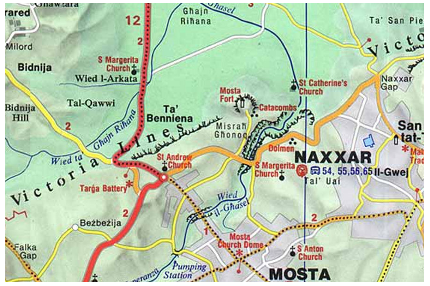
Around Mosta
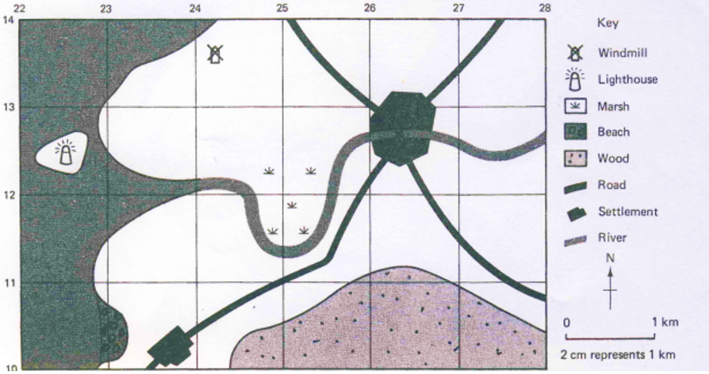
The countryside
|
2. COMPASS AND DIRECTIONS
|
🡺 I can use a compass and give directions.
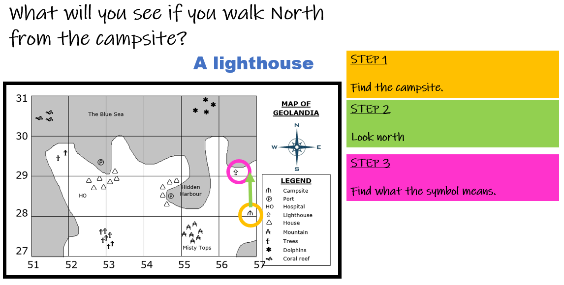
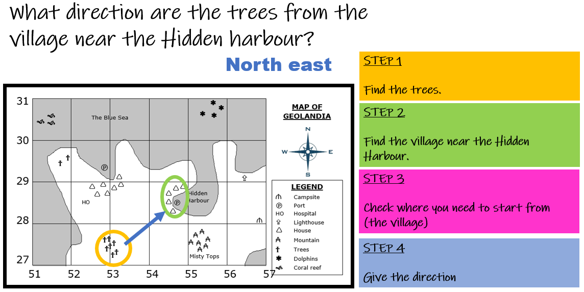
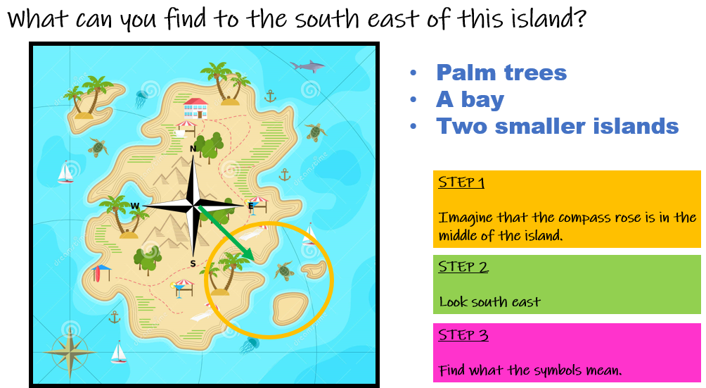
To measure the direction to/from a place we use a compass. Places are shown by the direction they are going to. The four main points of the compass are north, east, south and west. Halfway between each of these there are four other points: north-east, south-east, south-west and north-west. This makes an eight-pointed compass. Maps are usually printed so that north is at the top of the map. 
Click on the image above to test your compass and directions skills!
|
|
Geo-check!
|
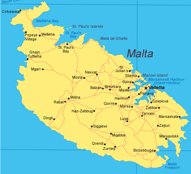
1. Look at a map of the Maltese towns and villages name FOUR settlements which are located:
2. Look at a map of the Maltese towns and villages again and imagine you are located in Attard, in the centre of Malta. a. In which direction is is your hometown? b. In which direction is the airport? c. In which direction is our capital city? d. In which direction must you travel to catch the ferry to Gozo? e. In which direction is Filfla? 3. Imagine you are a tourist and want to travel around Malta. Fill in the blanks below with directions.
4. Mark this route on the map (in pencil). |
|
3. SCALE AND DISTANCE
|
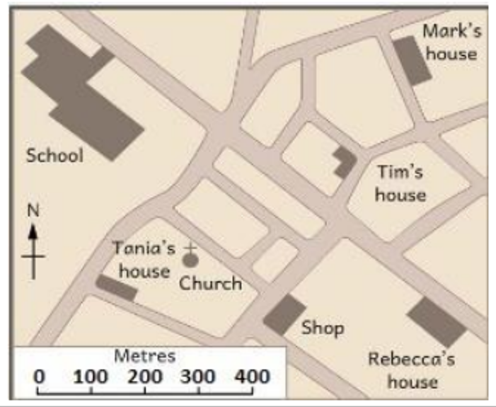
🡺 I can measure distances using a linear scale.
The drawing below is an example of a scale line. This scale line tells us that every 1 cm (centimetre) on the map represents 100 m (metre) on the real ground. If we apply the scale line to the school or street map, we may be able to find how large the rooms are or how long the roads are. The scale line shows the exact proportion between the measurements of the plan and the measurements of the real ground. 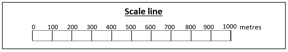
|
|
Geo-check!
|
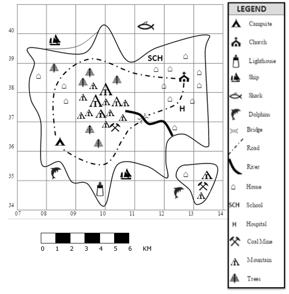
1. Calculate the distance (to the nearest KM) from the school to the:
a. Church b. Hospital c. Coal mine on the main island d. Shark e. Ship to the north of the island f. Campsite 2. Using the string, find the distance (to the nearest KM) of the following features: a. The river b. The road c. The coast of the small island |
|
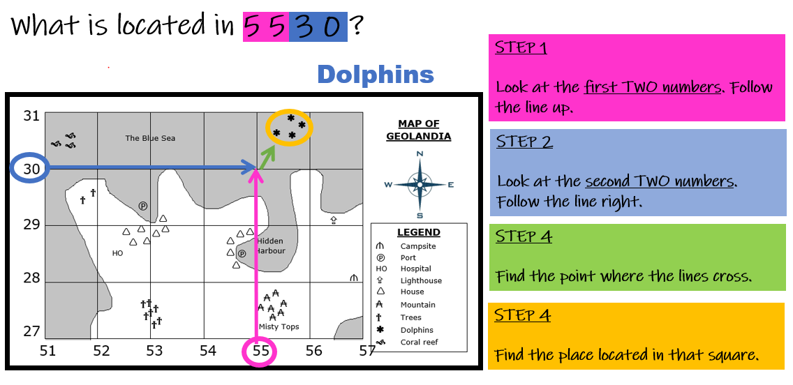
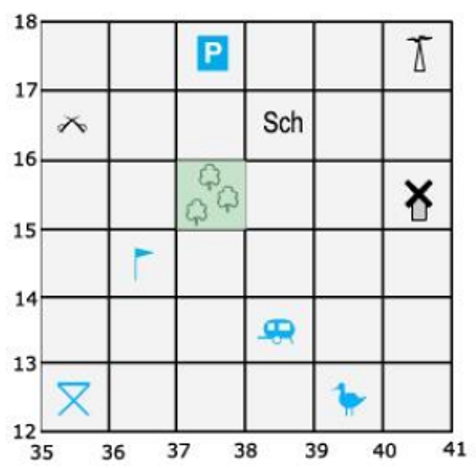
4. GRID REFERENCES
|
🡺 I can find and give grid references.
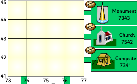
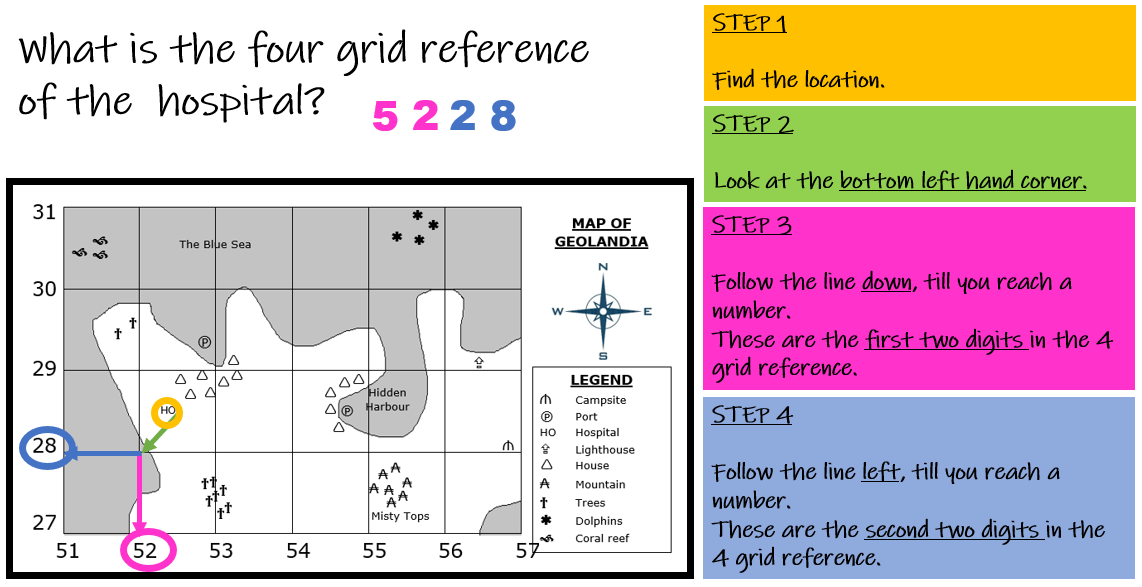
Notice that the map is divided into a number of squares, all of equal size. Each square is called a grid square, while all the squares together are called the grid. This grid helps us locate the exact position of a place on the plan. Locating, or finding out, the position of a place on a plan is like a simple game. Four-figure grid references can be used to pinpoint a location within a square. To find the number of the square:
Click on the image above to test you skills on grid references!
|
|
Geo-check!
|
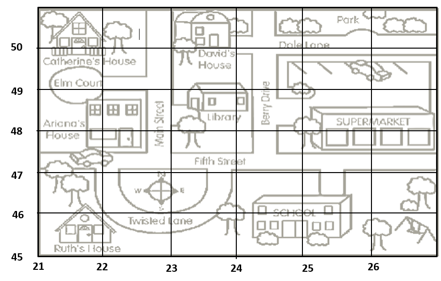
1. Fill in the blanks with the correct four grid reference/s or location using the street map.
a. David’s house b. Ruth’s house c. The swing d. Berry Drive e. 2149 f. 2150 g. 2348 h. 2246 i. 2445 and 2545 j. 2247, 2248, 2249 and 2250 |
|
Geo-check! - EXTRA EXERCISES!
|
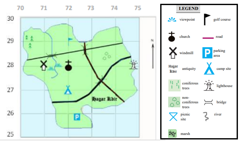
1. Examine Map 1
a. Answer the following questions by filing in the correct answer.
b. On the map, draw a picnic site in grid square 7427. c. Imagine that your friend is going to visit this island. Write four sentences to describe the island to your friend. 2. Examine Map 2.
3. Examine carefully Map 3. a. In which grid squares are the following symbols found?
b. Draw the following symbols in the given grid squares:
|
|
Geo-check!
1. Watch
